

Favorite Poweboating Apps
 12-13-2013 | 02:25 AM
#1
Thread Starter
Registered

Joined: Jun 2010
Posts: 1,395
Likes: 930
From: LBC, OH
What's everyone's favorite boating apps, and why?
[HR][/HR]
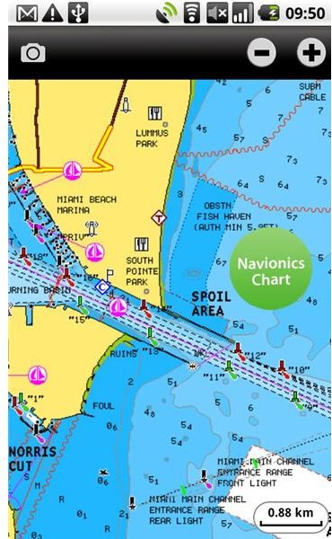
I've found this little chart plotter app from Navionics pretty handy, especially when boating outside of cell service. It downloads the maps and stores them locally on your phone or tablet, so it doesn't require an internet connection to function like Google Maps/Earth. You can however overlay Goggle Earth images on top when you do have cell service. That's a pretty cool feature. Includes other nice features like search, tide charts, bookmark your locations, and the ability to tag photos for others. Plus displays your GPS heading and speed on the screen while running.
Can be a little tricky to understand the menus at first, but contains the main things ya really need like depth, nav markers, and landmarks such as marinas or boat ramps for about anywhere your gonna be in the US. Also contains a nice "track" feature that allows ya to save your running data to review on a PC based map later. Or at minimum, for following your day track back to the ramp in the pitch dark. Found that part extremely useful this summer on our first trip to Lake Cumberland, returning the 20 or so miles to Burnside ramp from State Dock after dark..
It's no high dollar plotter, but works fine in a pinch for under $10
--
p.s. can someone with admin rights put the R in power under the title please...
[HR][/HR]
I've found this little chart plotter app from Navionics pretty handy, especially when boating outside of cell service. It downloads the maps and stores them locally on your phone or tablet, so it doesn't require an internet connection to function like Google Maps/Earth. You can however overlay Goggle Earth images on top when you do have cell service. That's a pretty cool feature. Includes other nice features like search, tide charts, bookmark your locations, and the ability to tag photos for others. Plus displays your GPS heading and speed on the screen while running.
Can be a little tricky to understand the menus at first, but contains the main things ya really need like depth, nav markers, and landmarks such as marinas or boat ramps for about anywhere your gonna be in the US. Also contains a nice "track" feature that allows ya to save your running data to review on a PC based map later. Or at minimum, for following your day track back to the ramp in the pitch dark. Found that part extremely useful this summer on our first trip to Lake Cumberland, returning the 20 or so miles to Burnside ramp from State Dock after dark..
It's no high dollar plotter, but works fine in a pinch for under $10
--
p.s. can someone with admin rights put the R in power under the title please...
Last edited by kidturbo; 12-13-2013 at 02:39 AM.
 12-23-2013 | 11:10 PM
#3
Thread Starter
Registered
Joined: Jun 2010
Posts: 1,395
Likes: 930
From: LBC, OH
Here is another useful app for out on the water.
Radar Now is simply a free doppler radar app. Soon as you open it up, puts your current location at the center of the radar screen based off the GPS. So if your out boating and see storm clouds on the horizon, it gives ya the animated radar view of where you are right now, not where you last checked conditions like most other weather apps.
Second nice feature I've found is the NWS Alerts. Again based on your GPS location, it provides pop up alerts when severe weather is approaching. That's something I think every boater can appreciate...
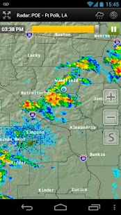
From the developer.
Weather radar in your pocket! Use RadarNow! to quickly see an animated radar image and current conditions! No digging through menus to see if a storm is on the way!
RadarNow! provides National Weather Service (NWS) Enhanced Radar "Base" (N0R) images from the NOAA WSR-88D NEXRAD Radar sites located around the U
NWS Alerts included with the free mode starting in v4.0. Only alerts issued to the your current county are sent and the alerts can be filtered so only the ones that interest you are used.
Android Link
Itunes Link
Radar Now is simply a free doppler radar app. Soon as you open it up, puts your current location at the center of the radar screen based off the GPS. So if your out boating and see storm clouds on the horizon, it gives ya the animated radar view of where you are right now, not where you last checked conditions like most other weather apps.
Second nice feature I've found is the NWS Alerts. Again based on your GPS location, it provides pop up alerts when severe weather is approaching. That's something I think every boater can appreciate...
From the developer.
Weather radar in your pocket! Use RadarNow! to quickly see an animated radar image and current conditions! No digging through menus to see if a storm is on the way!
RadarNow! provides National Weather Service (NWS) Enhanced Radar "Base" (N0R) images from the NOAA WSR-88D NEXRAD Radar sites located around the U
NWS Alerts included with the free mode starting in v4.0. Only alerts issued to the your current county are sent and the alerts can be filtered so only the ones that interest you are used.
Android Link
Itunes Link
Last edited by kidturbo; 12-23-2013 at 11:23 PM.

 12-27-2013 | 12:55 PM
#7
Gold Member
Joined: Jan 2006
Posts: 765
Likes: 1
From: Edgewater, MD
Check out www.fishweather.com or search for their app. One of the best winds apps that I could find and is very accurate.
01-07-2014 | 02:08 PM
#10
Thread Starter
Registered
Joined: Jun 2010
Posts: 1,395
Likes: 930
From: LBC, OH
* No Screen Lock disables the automatic screen timeout / lock feature that's seems to be missing in the Android version with a single icon click.
* Screen Filter further dims the back lighting or shades the screen to an acceptable level for night running.

