

Chesapeake Bay - Sandy Anchorages
 05-25-2017 | 09:06 AM
#11
Thread Starter
Registered
Joined: May 2017
Posts: 9
Likes: 0
I've got Battery Island, but I'm not sure where the best approach is for this spot. There's a channel that comes in South of it and then goes up behind it. Where do you typically drop anchor (north, east, south, or west of it)? Remember, I'm putting this together for people that don't have a super shallow draft too, (think inboards that require 3'-4' of depth).
Someone has already mentioned Sand Island, but I'm not finding it on the google maps or the charts. Is that the little island just west of Battery Island?
For Huckleberry Point are you talking about the sandy beach on your starboard side as you enter before you actually get to the point? Because the charts are only showing 1'-2' of water once you reach the point and past it. And can you go ashore there, or is that a private beach?
 05-25-2017 | 09:17 AM
#12
Thread Starter
Registered
Joined: May 2017
Posts: 9
Likes: 0
I see a small spot just in side that channel to starboard that's got 8' of water, but it looks like the majority of that area in the back is 2'-3'. For boats that need more depth, is that large beach on the outside about mid way across the peninsula a good spot to anchor too?
05-25-2017 | 10:10 AM
#13
Gold Member
Joined: Apr 2006
Posts: 1,479
Likes: 5
From: St. Cloud, FL
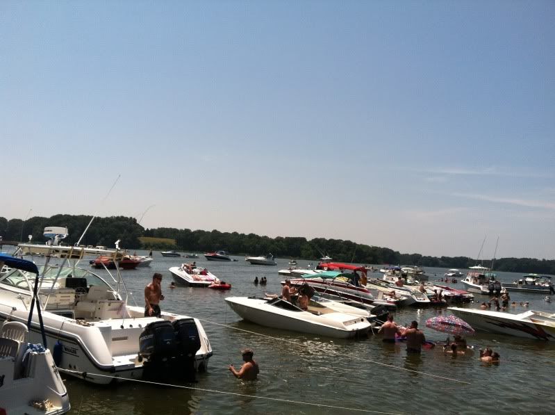
I see a small spot just in side that channel to starboard that's got 8' of water, but it looks like the majority of that area in the back is 2'-3'. For boats that need more depth, is that large beach on the outside about mid way across the peninsula a good spot to anchor too?
This is a pic from a couple years ago inside Lloyd's. You can see a couple larger boats in there.
 05-26-2017 | 08:57 AM
#15
Thread Starter
Registered
Joined: May 2017
Posts: 9
Likes: 0
The list is growing... started with 6 I had personal knowledge of and now it's up to 34 that stretch from the top of the bay all the way down to the mouth! Keep em coming, especially if you know of any spots between the bottom of Kent Island all the way down to the Rappahanock.
Just remember, we're looking to add "Sandy Bottom" anchorages with waters shallow enough to step off the boat and stand with your head above water, (4'-5' deep). Having a walk up sandy shoreline or beach is a plus.
https://www.google.com/maps/d/edit?h...9010000001&z=7
******************
And for those of you that enjoy a good Dock Bar on the Chesapeake Bay, here's my personal list of those too. It's publicly available so feel free to bookmark it as a reference:
https://www.google.com/maps/d/edit?h...76.4953385&z=7
05-26-2017 | 01:21 PM
#16
Registered
Joined: Mar 2011
Posts: 448
Likes: 1
Can't get lat lon from where I'm at but on Eastern Shore of VA just north of the CBBT is Sunset Beach resort. It's a nice spot with small seasonal restaurant on shore that normally has live music on at least one day each weekend and a nice sand bottom. It's a little exposed if the weather is bad but it's another nice spot, I've always heard it called Tiki Bar locally. Decent food and nice small beach that you can get to from shore or by water.
The only trick to it is there are several layers of sand bars as you get closer to shore so if you come in at high time pay attention because depending on draft if you stay till low tide you may be stuck until the tide comes back in.
Another spot is off Chippokes Plantation State Park up the James River just South of Jamestown. There's a HUGE party there every July normally shortly after the 4'th of July weekend called PPP. There's normally not many people other weekends but it's pretty protected with a nice bottom. No real beach access though, just shallow sand bottom nice for relaxing. For PPP weekend the party is on Sat and will have "rings" of participation with the inner rings being pretty rowdy, think mardi gras on the water, but it gets tamer to the point of kid friendly on the outskirt. Definitely have a DD if you come there for PPP weekend as the water patrol is heavy for boats leaving but they don't bother the party.
05-26-2017 | 01:25 PM
#17
Registered
Joined: Mar 2011
Posts: 448
Likes: 1
Almost forgot Paradise Ocean Club is off what used to be Fort Monroe just North of the Hampton Roads Bridge Tunnel at the old Officer Club turned private club / restaurant. Anyone can anchor off the beach but the drop off from shore is pretty steep and if the bay is rough not a great option because there's no protection. If the weather is nice it's great because you can hang out in the water or go up to the beach where there's a bar, restaurant, and pool.
 06-13-2017 | 09:06 AM
#19
Thread Starter
Registered
Joined: May 2017
Posts: 9
Likes: 0
Crickets out there... I guess we've collectively put together every single shallow sandy anchorage on the bay! ;-)
I'll continue to update the map as long as I keep getting contributions. And the map will remain free and publicly accessible to anyone who wants to use it to explore (new to you) sandy anchorages around the bay. Thanks to everyone who's contributed so far!
https://www.google.com/maps/d/edit?h...6.19621515&z=7
06-13-2017 | 10:08 PM
#20
Registered
Joined: Aug 2016
Posts: 61
Likes: 0
From: PA
I need a little help with these...
I've got Battery Island, but I'm not sure where the best approach is for this spot. There's a channel that comes in South of it and then goes up behind it. Where do you typically drop anchor (north, east, south, or west of it)? Remember, I'm putting this together for people that don't have a super shallow draft too, (think inboards that require 3'-4' of depth).
Someone has already mentioned Sand Island, but I'm not finding it on the google maps or the charts. Is that the little island just west of Battery Island?
For Huckleberry Point are you talking about the sandy beach on your starboard side as you enter before you actually get to the point? Because the charts are only showing 1'-2' of water once you reach the point and past it. And can you go ashore there, or is that a private beach?
For Huckleberry Point, yes it is on the starboard side as you enter. The charts aren't quite right in that area. We anchor about 15 feet off the beaches and have about 4-5 ft of water. We also ski and wakeboard all up and down that cove and have enough draft.
The only one that I frequent that I dont see on there is the Susquehanna Flats (as we call them). It is located right off of Stump Point and Poplar point and is right off the main channel that goes through there. On the weekends you will be able to see the raft up of lots of boats. Its tricky to get to just because of the depths. You need to either come down the main channel from Havre De Grace or come from the North East Side around Carpenter Point (which I dont recommend unless its high tide and you are familiar with the area. The channel here is very small and unmarked)
Excellent list. Keep up the good work.

